Field validation
70+ acre deployment
Tested across varied terrain
MSITU
and the catalyst to tree planting.
RTK-precision marking and pegging on Android — so grids stay true, crews move faster, and forests come back where they belong.
Introduction
Reforestation is urgent, but the bottleneck is often invisible: how accurately you mark and peg before the first seedling goes in.
Climate change, prolonged dry seasons, flooding, soil erosion, increased atmospheric greenhouse gases, global warming, and lack of biodiversity — all of these have deforestation in common.
Between 2001 and 2002 alone, Uganda lost 290 ha of tree cover, about a 15% decrease. Coverage has remained under pressure since 2000, and systematic cutting continues with too little replanting to match.
Reforestation is the obvious path forward — yet the practical work of getting trees in the ground at scale is harder than it sounds. Traditionally there are four steps, with trees planted in a square mesh so opposite trees stay equidistant:
Preparation
Land cleared and ready for planting.
Marking
Ropes and spacing laid to the planned grid.
Pegging
Plot fixed to the ground before seedlings arrive.
Planting
Seedlings set where the mesh says they belong.
The problem
As hobby and community foresters, the team replanted where trees had been removed — commercially and voluntarily. The bottleneck kept appearing at the marking stage.
Across several acres, rope-based pegging is tedious, easy to misalign, and slow. Small measurement errors compound into wasted land, rework, and lost planting days.
Solution · System · Field validation
Field validation
70+ acre deployment
Tested across varied terrain
System
RTK base station
Fixed correction reference
Field validation
Hybrid pegging method
Less marking, better speed
System
RTK rover
Mobile point capture in the field
Outcome
Planting momentum
More forestry, less rework
Solution
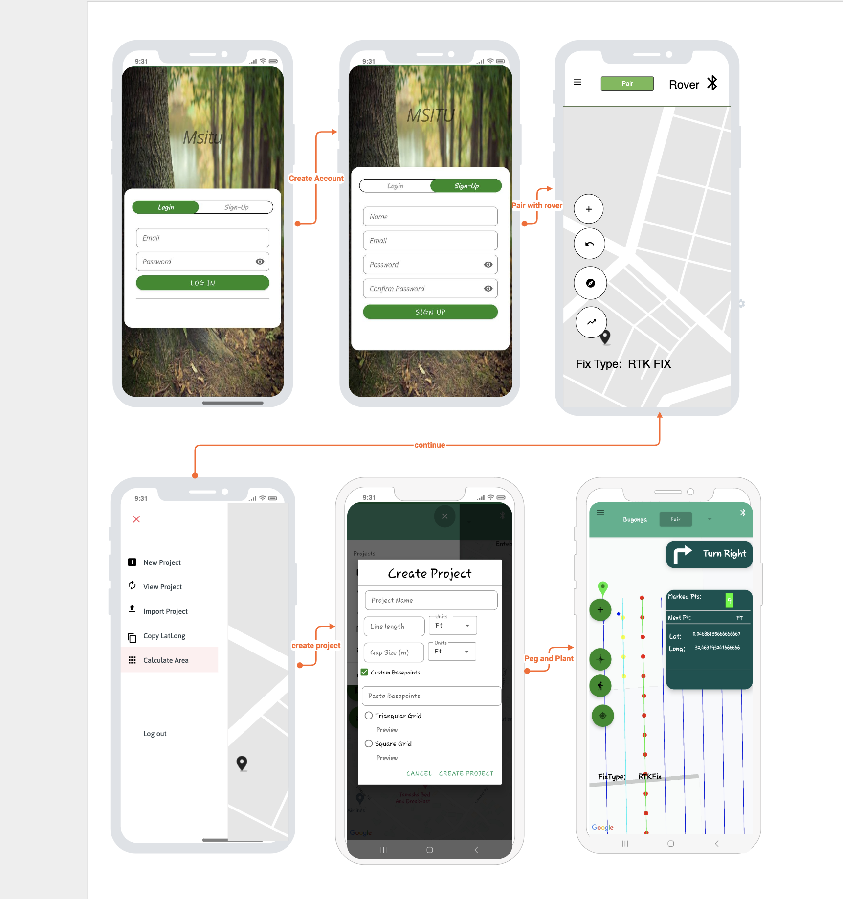
MSITU app
Project setup in minutes
Active card
Solution
Create a marking project from name, gap size, and line length. Connect to rover by Bluetooth or USB and start field layout fast.
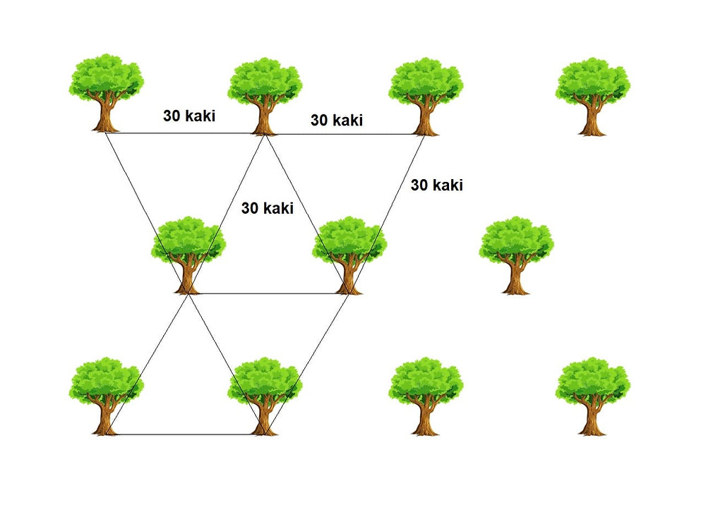
Layout
Same land, different geometry. MSITU favors equilateral triangular spacing so nearest-neighbor distance stays consistent in every direction, improving land use and planting density.
Square risk
Diagonals stretch longer than edge spacing.
Triangle gain
Equal nearest-neighbor distance in all directions.
Outcome
Better land utilization and tighter planting flow.
Edge points may be evenly spaced, but diagonals are longer. At 10 ft edge spacing, diagonals approach ~14 ft, which creates dead pockets and lowers planting density at scale.
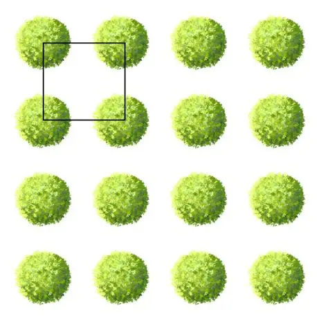
Trees sit on equilateral triangles, keeping nearest-neighbor spacing consistent around each point. This reduces wastage and improves practical planting density.
Open source collaboration
The MSITU app is functional and field-tested, with clear room for growth. It is open source, and the team welcomes contributors, technical partners, and organizations interested in building the next version together.
View repository: github.com/dsmagicug/msituProof of concept
Using the Msitu app and triangular mesh, the team planted several acres of new forest in Mukono. The videos show full-grown forest that was planted using the MSITU app workflow.
Team & collaboration
From precision field layouts to long-term canopy growth, MSITU is built with communities, growers, and implementers who want practical climate action that lasts.
“A nation that destroys its soils destroys itself. Forests are the lungs of our land, purifying the air and giving fresh strength to our people.”
Contact
Reach out if you want to plant trees with MSITU. We support partnerships, pilot deployments, and field coordination, then guide your next practical step.